Maps (Part 4): Symbolism

Maps are full of symbols. Map legends, markers, and conventions of orientation help interpretations. For example, the size of the dot for a city can indicate its population or size. Subway systems are simplified into schematic lines and bars or circles. The most common form of mapping is a two- dimensional projection of a three-dimensional world. The distortions of a flattened earth is not necessarily recognized consciously or immediately. A common example is the Mercator projection that exaggerates the size of the polar areas. Using unusual projections can help us “see” the world with new perspectives that may enhance problem solving and creativity. This map in the Dymaxion or Fuller projection highlights continuity of lands. A similar but different one does the same for oceans.

No less than the flag to represent a nation, a map reveals the identity, aspirations, and imaginations of the realm as revealed by the map-maker. From the earliest Ptolemy map of the stars to the latest images taken from satellites, each map reveals both the explicit and implicit worldviews of the cartographer. An early example is the Ebstorf Map produced in medieval times. In the center of the map is Jerusalem, the city at the center of faith and authority at that time. Christ is at the top, part of and overseeing the world. Details of the map contain historical, religious, and geographical significance. It can be used as an atlas, as a chronicle of the world, or as an illustrated bible. “All this...in the name of Christianity…to project a history of Christian creation, salvation and judgement onto the surface of a map” (Brotton, 2013).

This map of Europe in late 19th Century uses symbolic characters to caricature the nations' conditions.

Source: Maps on the Web blog (see link)
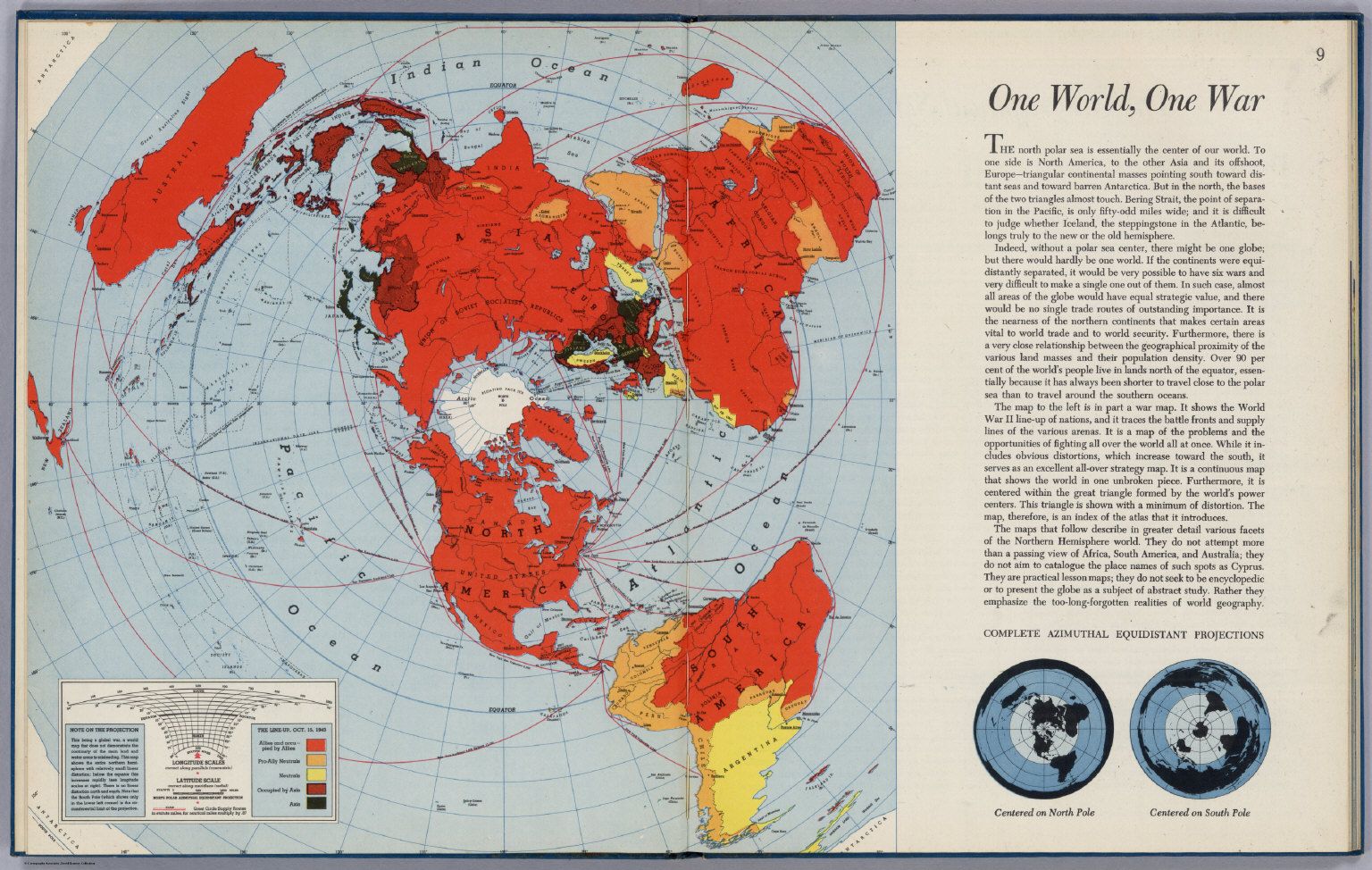
A more recent example closer to home is the appearing of maps symbolizing the power and influence of the United States during and after WWII. Just as Jerusalem occupies the center of the Ebstorf Map, Richard Edes Harrison’s polar azimuthal projection of the world first published in 1941 shows USA at its center, as a nation extending its power of lend-lease aid outward into the world. "The entire conflict pivots around the US."
Another map showing United States prominently as the center of the world is seen in this map, the basis for the original UN emblem. A year later, the world was tilted to make this symbolism less obvious.

Lest anyone thinks this is just one nation’s exercise, on the opposite side of the world is the dragon rising. In Everything Under the Heavens, Howard French describes China’s resurgence for global power from its century of National Shame. In 2009, China displayed a map with a “drooping segmented line that encloses 90% of the South China Sea...now popularly known as the “nine-dash line.” A version of this map is printed in Chinese passports as a symbol of sovereignty, even as the world debates the legitimacy of China's claims.

The last map of symbolism I want to present is an old map of North America that shows unexplored areas of its times. In maps of antiquity, blank areas are often also surrounded by sea monsters as symbols and reminders of our ignorance. Again, our dependence on all-knowing Google has reinforced an illusion of knowledge. Sometimes we know what we don't know, but the greater dangers lie in what we don't know we don't know.

I hope this series of blogs of maps as metaphors, analogies, parables and symbols will be an encouragement to see our "world" more carefully, creatively, and contemplatively.
***
References:
Brotton, J. (2013), A History of the World in Twelve Maps, Penguin
French, Howard W. (2017) Everything Under the Heavens: How the Past Helps Shape China’s Push for Global Power, www.aaknopf.com
Immerwahr, Daniel. (2019) How to Hide an Empire: a History of the Greater United States, Picador

1 comments
"Sometimes we know what we don't know, but the greater dangers lie in what we don't know we don't know."
ReplyDeleteVery true... The Dunning-Kruger Effect is very much a danger in many areas of life!